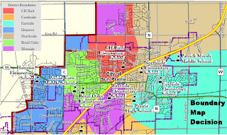
 Is the boundary issue dead...or are the embers silently smoldering? During recent interviews for the heir to Jim Carrel's school board seat, board president David Stackhouse asked each candidate a question that wasn't on the prepared question list. Stackhouse asked of each,
"Is the boundary issue resolved?"
Logic would seem to dictate that it is in the board's best interest to keep the dead buried....so why did Stackhouse ask the question? Was he looking for another ally to rally the issue? Or was his intent to exclude from consideration any candidate that indicated the issue was not resolved?
Why were people affected by the decision so distraught? Certainly the board's way of coming to a decision had a lot to do with things, but the map also clearly points out the disconnection in a district that claims to place high value on "connectedness". Take a look at the island the board created (the purple region north of Egre road and west of Bird St). These students were leapfrogged over both Bird and Northside to be placed at Westside. Does this make sense? Shouldn't the primary rule for developing boundaries be to draw lines for any individual school to form a single polygon? Isn't THAT what facilitates development of "neighborhood" schools? Now consider ...for a minute...just ONE alternate map (at right). Certainly, the numbers of students was not considered in creating this quick version, but logically, does it not make more sense?
This was never about allowing people to stay with a beloved school but rather about making a decision which makes no sense.
Download or view the full-size District elementary boundary maps.
......THIS?...................or THIS?


